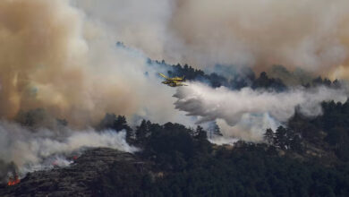
Scientists warn that these types of extreme weather events, affecting countries all over the world, may become increasingly common as the climate crisis accelerates, putting pressure on governments to prepare.
“Global warming actually changes the properties of precipitation in terms of frequency, intensity and duration,” said Jung-Eun Chu, an atmospheric and climate scientist at the City University of Hong Kong – though she added that this summer’s devastation was due to a combination of different factors including natural climate fluctuations.
The huge toll of the floods also highlights the urgent need for governments to prepare for this new reality, and the ways conflict-ridden and poorer countries sit on the front lines of climate disasters.
Governments “have to be ready,” said Chu. “They have to start thinking about it, because they’ve never experienced these kinds of extreme events before.”
One of the worst storms in Europe
This month, swaths of the Mediterranean region have been lashed by Storm Daniel, the result of a very strong low-pressure system that became a “medicane” – a relatively rare type of storm with similar characteristics to hurricanes and typhoons which can bring dangerous rainfall and flooding.
The storm, which formed on September 5, affected Greece first, releasing more rain than is normally seen in an entire year. Streets turned into deadly rivers, submerging whole villages and forcing emergency workers on inflatable boats to rescue families from their flooded homes.

At least 15 people died, according to the Greek Prime Minister Kyriakos Mitsotakis, who called it “one of the most powerful storms to ever hit Europe.”
The floods, which followed devastating wildfires in the country, “have the fingerprints of climate change,” Greek environment minister Theodoros Skylakakis told CNN on Tuesday.
“We have had the warmest summer on record. The sea was very warm, which lead to this unique meteorological event,” he said.

Neighboring Turkey felt the impact too, recording at least seven deaths. Residents in wooded areas had to wade through knee-high water, surrounded by fallen trees – while parts of Istanbul, the country’s biggest city, saw deadly flash floods which killed at least two people.
Severe flooding also struck Bulgaria, north of Greece, with at least four deaths confirmed.
Elsewhere in Europe, a separate storm – Storm Dana – saw torrential rain across Spain, damaging homes and killing at least three people.
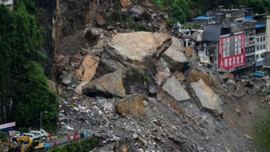
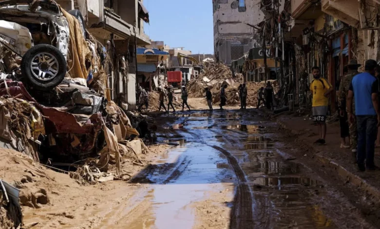
Devastation in Libya
By far the most devastating impact was felt in Libya, as Storm Daniel moved across the Mediterranean, gaining strength from the sea’s unusually warm waters, before dumping torrential rain on the northeast of the country.
The catastrophic rainfall caused the collapse of two dams, unleashing a 7-meter (23-foot) wave, according to the International Committee of the Red Cross (ICRC). The water rushed toward the coastal city of Derna, wiping out entire neighborhoods and sweeping homes into the ocean.
More than 11,000 people are dead and at least another 10,000 still missing, according to the UN, with many believed to have been swept out to sea or buried beneath rubble.
As the nation reels, and as search and rescue operations grow desperate, experts say the scale of the disaster has been greatly magnified by a combination of factors including crumbling infrastructure, inadequate warnings and the impacts of the accelerating climate crisis.
“This is a tragedy in which climate and capacity has collided to cause this terrible, terrible tragedy,” said UN aid chief Martin Griffiths on Friday.
Libya has been wracked by a civil war and a political standoff for almost a decade, with the nation split between two rival administrations since 2014 – one of which isn’t recognized by most of the international community, and which controls the region where Derna is located.
The North African country’s fragmented state has made it unprepared for the flooding, experts say, and may hamper delivery of urgently needed humanitarian aid.
“The situation in Libya has been steadily deteriorating due to years of conflict and instability, compounded by the impacts of climate change,” said Ciaran Donnelly, senior vice president for crisis response, recovery and development at the International Rescue Committee.
“Globally, climate change has made these extreme weather events more frequent and intense, making it even harder for communities to cope and rebuild, especially in conflict-affected regions,” he added.
Asia’s dueling typhoons
While the scale of devastation and loss of human life was smaller in Asia, it has also reckoned with deadly and unprecedented storms.
Two typhoons – Saola and Haikui – passed through the region within days of each other during the first week of September, causing widespread damage in the self-governing island of Taiwan, the city Hong Kong and other parts of southern China including Shenzhen.
Though Typhoon Saola shut down Hong Kong schools and businesses for two days, the real damage came a week later when the city was lashed by a sudden storm, with flash flooding submerging metro stations and trapping ivers on roads.
The storm brought the highest hourly rainfall since records began in 1884, according to Hong Kong authorities.
In Taiwan, Typhoon Haikui left tens of thousands of homes without power, and more than 7,000 residents were evacuated.
The dual typhoons were an “exceptional case” that created the conditions for an unusually severe storm the following week, said Chu. The typhoons brought two slow-moving air masses, both heavy with moisture and traveling in different directions – which collided and dumped that water over Hong Kong
“If there were only one typhoon, it would not make this kind of severe precipitation,” she said. She added that while the event isn’t explicitly linked to climate change – the converging typhoons happened “by chance” – human-caused global warming is helping fuel stronger storms.
“If the climate warms, if the (ocean) surface becomes warmer, the atmosphere can hold more moisture,” she said. “If temperatures increase by one degree (Celsius), the atmosphere can hold 7% more moisture.”
She pointed to the history of hourly rainfall records in Hong Kong. In the past, there used to be decades between record-breaking rainfall events, Chu said, but gaps between records are narrowing rapidly. As our world warms, extreme weather that used to happen once in a lifetime are becoming more frequent occurrences.
Heavy rain in the Americas
Parts of the Americas have been inundated too. Brazil recorded more than 30 deaths last week after heavy rains and floods in the state of Rio Grande do Sul – the worst natural disaster to hit the state in 40 years, according to CNN’s regional affiliate CNN Brasil.
Brazilian meteorologist Maria Clara Sassaki told CNN Brasil that within a week, the state had received the average amount of rainfall expected for the entire month of September.
Meanwhile in the United States, the Burning Man festival made international headlines after a heavy rainstorm pummeled the area, with tens of thousands of attendees told to conserve food and water while stranded in the Nevada desert.
The remote area was hit with up to 0.8 inches – about twice the average September rainfall – in just 24 hours.
On the opposite side of the country, flooding in Massachusetts has damaged hundreds of homes, businesses and infrastructure including bridges, dams and railways. Rainfall in parts of Massachusetts and New Hampshire has been more than 300% above normal volumes over the past two weeks, according to weather service data.

Experts say record-warm ocean temperatures have fueled a hyperactive Atlantic hurricane season that shows no signs of slowing.
More than 90% of warming around the globe over the past 50 years has taken place in the oceans, according to the National Oceanic and Atmospheric Administration.
It means more storms are able to form than would otherwise be possible in a typical El Niño year, Phil Klotzbach, a research scientist in the Department of Atmospheric Science at Colorado State University, told CNN. Even storms that weaken due to changes in wind can stay alive and gain strength again once they find better conditions.
CNN’s Taylor Ward, Sana Noor Haq, Celine Alkhaldi, Eyad Kourdi, Hamdi Alkhshali, Mostafa Salem, Kareem El Damanhoury, Nadeen Ebrahim, Laura Paddison, Chris Liakos, Christian Edwards, Louise McLoughlin, Brandon Miller, Elizabeth Wolfe and Mary Gilbert contributed reporting.